CH3D is a Curvilinear-grid Hydrodynamics 3D model developed originally by Dr. Y. Peter Sheng at the Aeronautical Research Associates of Princeton, Inc. (ARAP, now part of Titan Corporation) during 1983-1986. (Sheng 1986, ARAP Tech Report; Sheng 1987, in "Three-Dimensional Models of Marine and Estuarine Hydrodynamics", Elsevier). After moving to the University of Florida (UF) in 1986, Dr. Sheng applied the CH3D to Chesapeake Bay (e.g., Sheng 1989; Sheng et.al, 1989; and Johnson et al., 1989; all in the Proceedings of the First International Symposium on Estuarine and Coastal Modeling) and James River (Sheng et al., 1989). Since 1989, Dr. Sheng's group (Advanced Coastal Environmental Simulations Lab) at the University of Florida has substantially enhanced the processes, numerical algorithms, and coding of the CH3D model through numerous studies on complex shallow estuaries (Indian River Lagoon, Tampa Bay, Sarasota Bay, Roberts Bay, Florida Bay, Charlotte Harbor, West Florida Shelf, St. Johns River, and Biscayne Bay, etc.), deep basin (Gulf of Mexico) and lakes (Lake Okeechobee, Lake Apopka). The latest version of CH3D is coded in Fortran 90 and runs on parallel platforms (e.g., SGI3400, SGI300, SGI2000, SUN, Intel-based systems, and Beowulf clusters) with a variety of operating systems (Unix, Linux, and Windows), and is substantially more efficient and robust than the earlier CH3D or other generic versions of CH3D out there. CH3D and CH3D-IMS are updated from time to time when a new process is added or a new algorithm is implemented, following sound software engineering principles.
The CH3D model uses a horizontally boundary-fitted curvilinear grid and a vertically sigma grid, and hence is suitable for application to coastal and nearshore waters with complex shoreline and bathymetry. The non-orthogonal grid enables CH3D to more accurately represent the complex geometry than the orthogonal grid, which is used by most other ocean circulation models. The model contains a robust turbulence closure model (Sheng and Chiu,1986; Sheng and Villaret, 1989, JGR) which enables accurate simulation of stratified flows in estuaries and lakes. Recent enhancements of the model includes modeling of aquatic vegetation, modeling of moving shoreline, addition of a sediment transport model, addition of a water quality model, and addition of a light/seagrass model, and parallel computing which leads to significant increase in computational speed. Recent applications have used horizontal grid on the order of 10-20 meters over a 200km x 50km area. A fully integrated modeling system CH3D-IMS has been developed and applied to several estuarine systems including the Indian River Lagoon, Tampa Bay, and Charlotte Harbor. The CH3D-IMS runs very efficiently - a one-year simulation takes 2-3 days. Parallel version of CH3D runs even faster on multiple-cpu shared- memory computer system such as the SGI Origin systems. Recent applications of CH3D and CH3D-IMS to integrated-scale and integrated-process modeling of large coastal and estuarine waters are summarized in Sheng et al. (2003), which appreared in Estuarine and Coastal Modeling, VIII, pp.407-422, ASCE.
CH3D-IMS, an integrated modeling system based on the curvilinear grid system of CH3D, includes circulation (CH3D), wave, sediment transport (CH3D-SED3D), water quality (CH3D-WQ3D), light attenuation (CH3D-LA), and seagrass models (CH3D-SAV). Additional processes (e.g., surface water - ground water interaction, atmospheric processes, contaminant transport, data assimilation) are being added.
CH3D-SSMS, An integrated modeling system for simulating storm surge and coastal inundation has been developed by coupling the wetting-and-drying version of CH3D with SWAN and REF/DIF. This modeling system uses the model results of a basin-scale surge model and a basin-scale wave model (for the entire Gulf of Mexico and the Western Atlantic) to provide the open boundary conditions for a coastal surge model (CH3D) and a coastal wave model (SWAN). The coastal surge model and the coastal wave model can be fully coupled or loosely coupled to produce high resolution (30-40 meters) inundation in many coastal regions (Charlotte Harbor, Tampa Bay, East Florida Coast, Biscayne Bay and Florida Bay, Northern Gulf of Mexico, and Chesapeake Bay). Results of the CH3D-SSMS can be used to (1)develop MEOW (Maximum Envelope Of Water) and MOM (Maximum of Maximum) for emergency planning, (2)develop Flood Insurance Rate Map (FIRM) for coastal counties and FEMA, (3) provide real-time forecast of surge, wave, and inundaion during a hurricane, and (4) forecast the expected beach erosion by coupling with a beach erosion model such as SBEACH.
CH3D-SSMS can use wind data from several soruces: NAM, HRD, WINDGEN, GFDL, WW-III, and the simple analytic wind model. Wind dissipation by varying land use types has also been incorporated into the wind fields used for CH3D-SSMS. Wave-surge coupling, both linear and non-linear, was incorporated into the model. High resolution Lidar topography data have also been used in many of the CH3D-SSMS simulations.
CH3D-SSMS has been applied to simulate the storm surge, wave, and coastal inundation in several coastal areas during the 2003, 2004, ans 2005 hurricane seasons. CH3D-SSMS was successfully applied to simulate the surge, wave, and inundation in Chesapeake Bay system and the Outer Banks area during Isabel in 2004. In 2004, CH3D-SSMS was successfully applied to simulate the surge, wave, and inundation during Hurricanes Charley, Frances, Ivan, and Jeanne. In 2005, CH3D-SSMS was applied to simulate Hurricane Dennis, Katrina, and Wilma. CH3D-SSMS generally produced good estimation of surge, wave, and wave setup in open water as well as high water mark (HWM) in inundated land areas.
To learn more about the CH3D and CH3D-IMS, read the CH3D and CH3D-IMS FAQ.
While CH3D and CH3D-based models have been used for conducting research in Sheng's group, other types of models have been developed and used as well. For example, we have developed a 3-D circulation model using the conservative Eulerian-Lagrangian Method (ELM) which is efficient and conservative. Unstructured grid models are also being developed. To allow ease of use in the operation of CH3D, including the generation of curvilinear grids, a GUI for CH3D is being developed. A complete Next-Generation CH3D and CH3D-IMS are expected by the end of 2004.
CH3D-SED3D CH3D-WQ3D CH3D-LA CH3D-SAV CH3D Graphic User Interface, Grid Editor Features Grid Editing, Grid & Other Data CH3D Grid for Indian River Lagoon CH3D Grid for Florida Bay Gulf of Mexico & Tampa Bay & Charlotte Harbor CH3D Grid for Charlotte Harbor CH3D Grid for Tampa Bay CH3D Grid for Biscayne Bay CH3D Grid for Sarasota Bay CH3D Grid for St. Johns River CH3D Basic Dimensionless Equations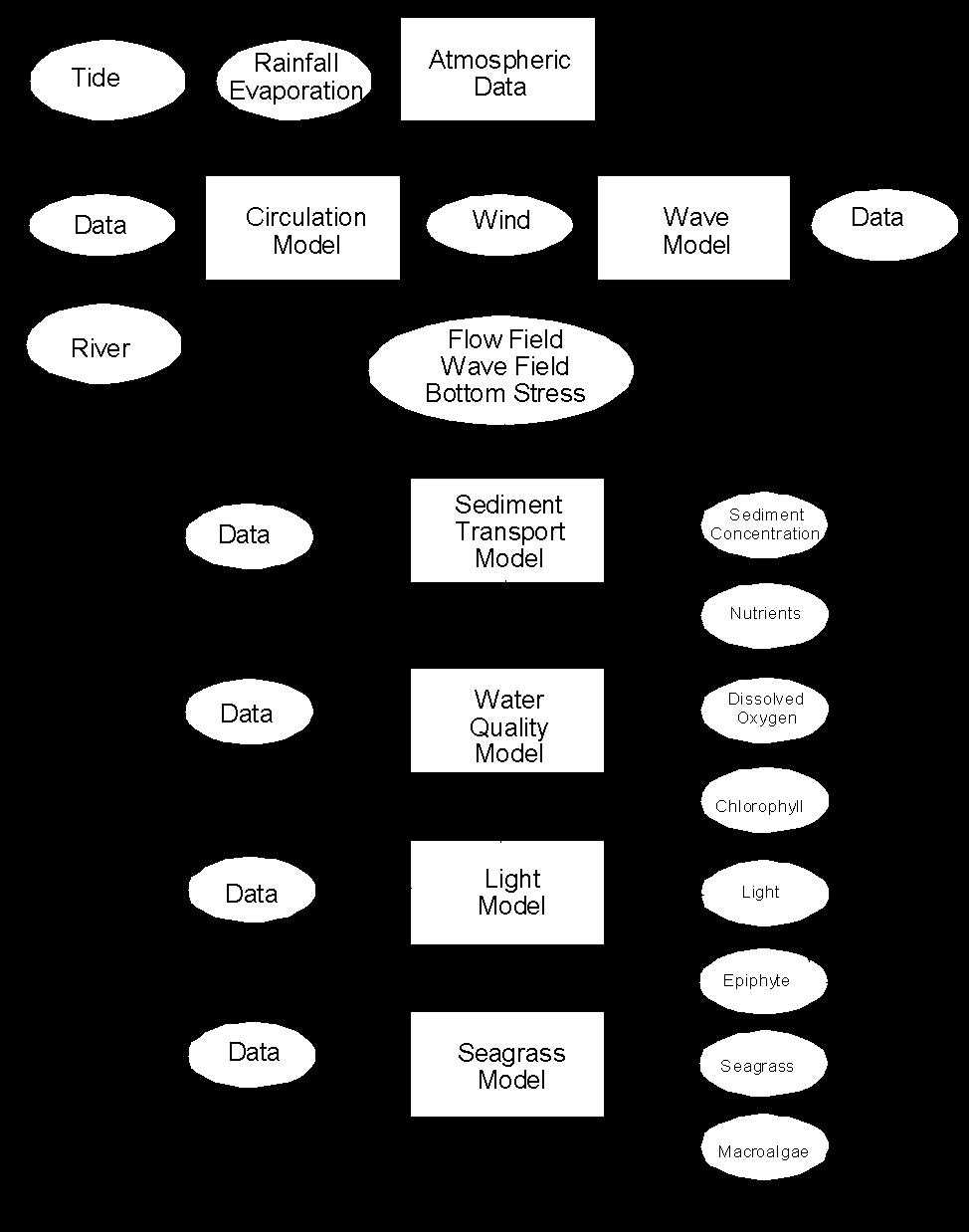